With the flight plan set the only thing missing before we can enter the cockpit is a set of charts. To quote Johan Andersson: “Everyone loves maps!”
Enroute Charts
Since I decided to use a rather direct route for my flight (see last posts), I don’t really need any enroute-charts, but I will briefly discuss what is available out there and how I usually use it.
Besides the obvious option of having a set of up-to-date official enroute charts, which is probably a bit on the expensive site for an occasional flight or two, there are some ways of getting similar results with online services.
The obvious choice here, again, is the freely available SkyVector, which provides great high and low altitude enroute charts. In case you want to fly even lower you are unfortunately out of luck unless you restrict yourself to the US. They have great VFR charts for the US, but they are very basic in other parts of the world (e.g. Europe). There is also the paid Navigraph Charts service. The quality of the maps seems to be comparable to the SkyVector service, but it does not offer a noticeable benefit over it justifying the price, in my opinion.
Unfortunately I don’t see a nice way of printing parts of enroute charts out right now. It would be great to have the option to select a certain route and then print out the matching segments of the enroute charts. Practically all this means that I mostly have a small notebook computer or a tablet sitting next to me showing SkyVector.
Airport Charts
In addition to the enroute charts we also need some information about the airports like taxiway-layouts, save departures and approaches etc.
For our flight we need to take into consideration the following types of charts:
- General
- Aerodrome
- SID
- STAR
- Approach
I will give a short description of each type and how they will be used on this flight.
The General Chart
The “General” chart, as the name suggests, will give you general information on the field in question. Most of these informations are only relevant if you really strive for realism and use a proper Air Traffic Control (ATC) service (i.e. PilotEdge). For our depature airport, CYZF, this chart is not even defined. For our destination, CYEG, there is some information on speed restrictions, how to fly circuits, a few notes on noise abatement procedures and what taxiways are accessible with what aircraft. None of these informations I particularly care about for my flight.
The Aerodrome Chart
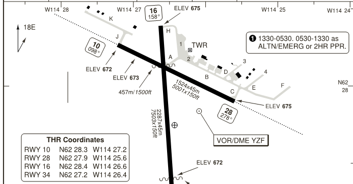
The Aerodrome chart provides a map of the airport, showing all the runways, taxiways, gates and parking positions. On a small airport like CYZF you shouldn’t have any problem finding your way to the runway, but I will need the chart nevertheless. Since the CIVA INS I will use on the Boeing 737-200 is not coupled to any GPS, I will need to provide it with position information when aligning it. This information can be obtained from this chart. Some charts already contain exact position listings for the gate positions, but all contain scales on the edges so that the position can be taken from the chart.

Figure 1 shows a part of the Aerodrome Charts for CYZF. You see that the threshold (THR) co-ordinates are directly printed on the chart. Since our 737-200 would be parked directly next to the tower (TWR) we could savely just use the runway 16 THR co-ordinates which is pretty close to it. In case you want a more accurate number you can take a look at the scales at the top and the right and interpolate the co-ordinates of the position you are interested in.
In this case I decide to print this chart out, but with a GPS-equipped aircraft I usually would not bother.
The SID Chart
Most larger airports feature a set of Standard Instrument Departures (SID). They simplify ATC handling of IFR flights while keeping the aircraft clear of terrain and obstacles. Since there is not a lot of obstacles around CYFR the chart for our flight is pretty simple. It merely states to keep flying runway heading until instructed otherwise and features some communication failure instructions, which is not an issue for our ATC-less flight.
For a simple chart like this I usually don’t bother printing it out.
The STAR Chart
The Standard Terminal Arrival Route (STAR) chart is a very important one for this flight.

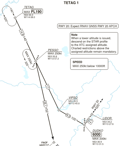
On an aircraft with a STAR-capable FMC this chart for my regular simulation needs would not be too interesting since I could just select from a drop-down list in the FMC and the aircraft would automatically follow it. Since the CIVA INS does not feature a navigation database it also has no clue what a STAR is. Thus I will later on have to manually enter the fixes of the STAR. Other than the lateral information this chart contains by providing the co-ordinates of the fixes, it also contains altitude and speed restrictions. Accordingly I usually print this chart out for usage during flight.
The Approach Chart
Since there are some clouds in the vicinity of the destination field I also check the published instrument approach for the expected runway 20. It turns out that this particular runway does not feature an ILS. Maybe it is only rarely, if ever, used in real life. I don’t care, this gives me a great reason to manually land the plane.
The published chart is based on the Nisku NDB situated ~4.5 nm from the runway threshold. Nothing exciting about the chart, I print it out regardless to get the altitude restrictions.
How to get the charts
Now to the question of how to get those charts. Again, if you are flying inside the US, you are good with just using the free SkyVector website. When you click on an airport it will give you a set of charts for it as pdfs ready for printing.
Outside of the US it gets bleaker. For Canada there is at least a set of pretty outdated charts available for each airport on the ivao.ca website. For Europe you are pretty much screwed if you are looking for a free offer (please correct me, if I am wrong).
Fortunately there is a paid service available, though. Navigraph with their Charts product provides both a desktop-client and cloud-based service featuring a lot of charts for airports around the world (also Europe). Charts can be individually bought and there is a subscription-based pricing model available, also.
Now with all the charts printed out we are finally ready to fire up the simulator and do the pre-flight setup of our aircraft.